

You can find on this page the Mexico cities map to print and to download in PDF. The Mexico map city presents main cities, towns and presents the capital of Mexico in Americas.
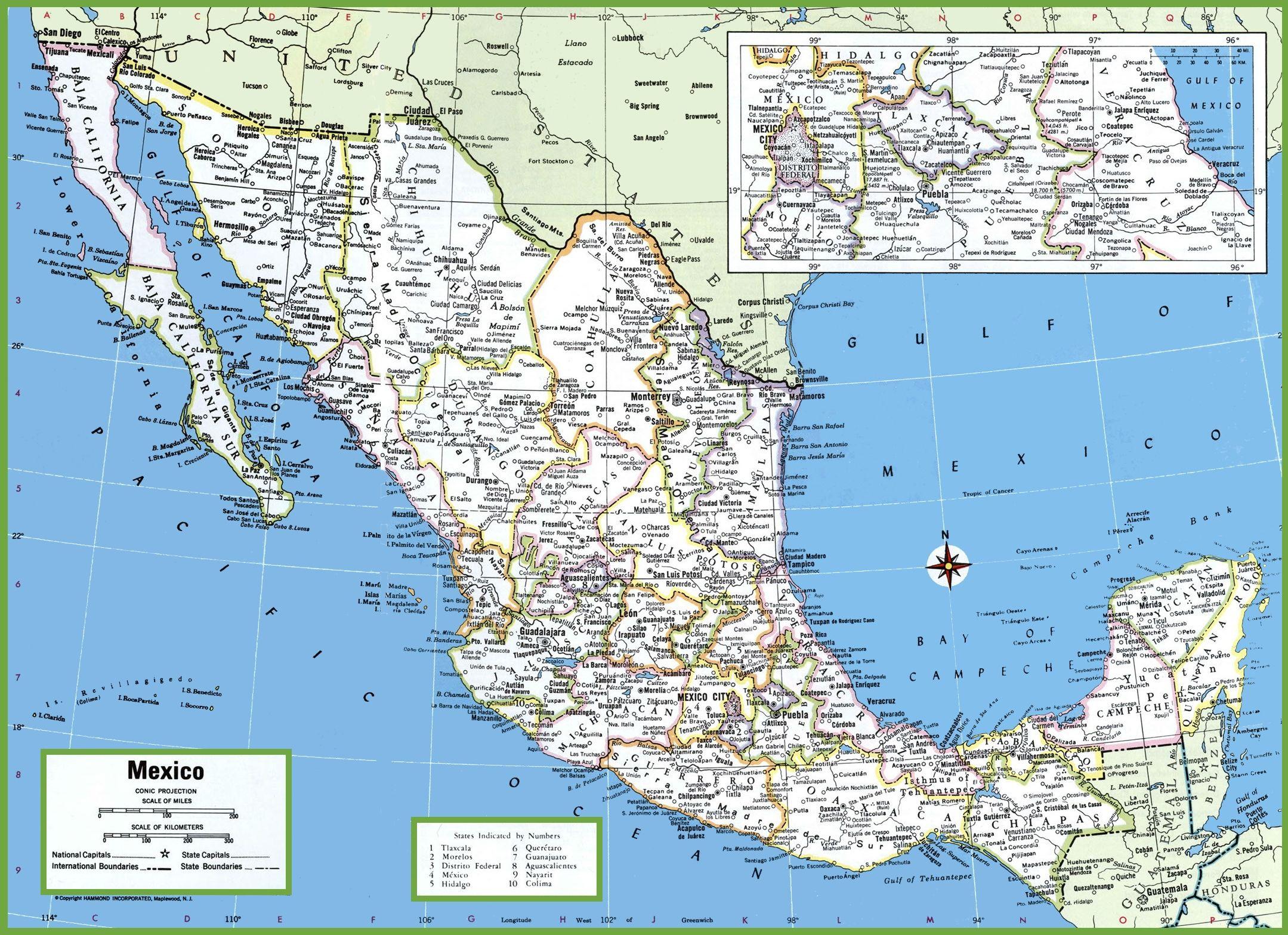
The map of Mexico with cities shows all big and medium towns of Mexico. This map of cities of Mexico will allow you to easily find the city where you want to travel in Mexico in Americas. The Mexico cities map is downloadable in PDF, printable and free.
Puebla city is one of the country oldest cities as its mentioned in the map of Mexico with cities, with a strong local culture, this is a colonial showpiece with a large historic center full of imposing Baroque and Moorish cathedrals and an array of extraordinary museums. Merida city has been the cultural and financial hub of the Yucatan Peninsula ever since the Spanish destroyed original Maya city and built their own walled city on top of it, using the limestone bricks of the old city. Queretaro city, this former mission headquarters and mining city boasts an immaculately preserved downtown adorned with 17th and 18th century buildings, quaint colonial-era plazas and lovely andadores, or pedestrian walkways, which are well used for evening promenades.
Mazatlan city, the "Pearl of the Pacific" is Mexico only beach destination that remains just as much a traditional colonial city as it is a resort area as youcan see in the map of Mexico with cities. Home to some of Mexico finest handicrafts, including the unique barro negro (black clay) pottery and alebrijes (intricate and brilliantly painted animal carvings), Oaxaca city seamlessly melds its Zapotec and colonial past with its vibrant present-day culture. Campeche city, perfectly outlined by the remains of the old city wall built in the 17th century to combat decades of plunder by pirates and buccaneers, the meticulously restored historic center of Campeche is a colonial time warp.
San Cristobal de las Casas city, lying in a valley high (6,890 feet) in the pine-covered mountains of Chiapas as its shown in the map of Mexico with cities, San Cristobal is one of Mexico best-preserved colonial towns, a vision of white stucco buildings crowned with red-tile roofs, narrow sidewalks lining cobbled streets and colorful markets in numerous open plazas. Guanajuato city is the prettiest of the old silver cities that grew from the mining camps northwest of Mexico City.

The map of Mexico with major cities shows all biggest and main towns of Mexico. This map of major cities of Mexico will allow you to easily find the big city where you want to travel in Mexico in Americas. The Mexico major cities map is downloadable in PDF, printable and free.
Mexico cities are spread among its 31 states and one federal district. The largest city, Mexico City, contributes over 12 million people to the country total population. In addition to Mexico City, there are also 11 other major cities that have populations that exceed one million as its mentioned in the map of Mexico with major cities. Over 100 cities have populations that exceed 100,000, while an additional 674 cities have populations that fall between 10,000 and 100,000 residents.
Greater Mexico City was the fastest growing metropolitan area in the country since the 1930s until the late 1980s. The next four major metropolitan areas in Mexico are Greater Guadalajara (4.1 million), Greater Monterrey (3.7 million), Greater Puebla (2.1 million) and Greater Toluca (1.6 million), whose added population, along with Greater Mexico City, is equivalent to 30% of the nation population as you can see in the map of Mexico with major cities.
Mexico medical infrastructure is highly rated for the most part and is usually excellent in major cities as its shown in the map of Mexico with major cities, but rural communities still lack equipment for advanced medical procedures, forcing patients in those locations to travel to the closest urban areas to get specialized medical care.
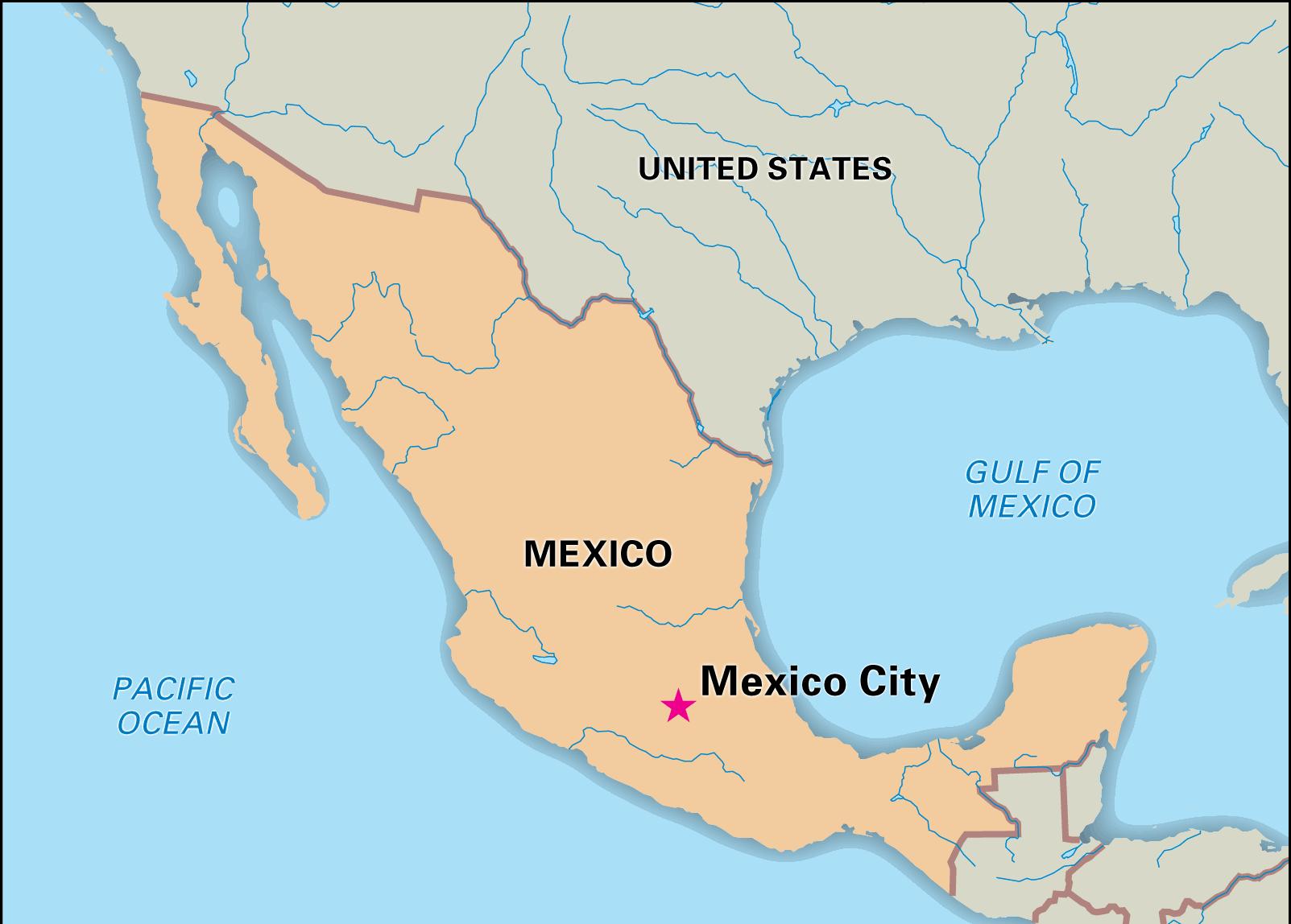
The capital of Mexico map shows the main city of Mexico. This capital map of Mexico will allow you to easily plan your travel in the capital of the country Mexico in Americas. The capital of Mexico map is downloadable in PDF, printable and free.
Mexico City (play /ˈmɛksɨkoʊ ˈsɪti/; Spanish: Ciudad de México [sjuˈðað ðe ˈmexiko], also known as México D.F., or simply D.F.) is the Federal District (Distrito Federal), capital of Mexico and seat of the federal powers of the Mexican Union. The choice of Mexico city as the capital of Mexico was official on November 18, 1824, as its mentioned in the capital of Mexico map and Congress delineated a surface area of two leagues square (8,800 ac) centered on the Zocalo.
Mexico City had served as the seat of government for both the State of Mexico and the nation as a whole. Texcoco and then Toluca became the capital of the state of Mexico. The two main candidates to become the capital were Mexico City and Querétaro. However, due in large part to the persuasion of representative Servando Teresa de Mier, Mexico City was chosen because it was the center of the country population and history, even though Querétaro was closer to the center geographically as you can see in the capital of Mexico map.
Mexico City is one of the most important cultural centers in the world, boasting more museums than any other city as its shown in the capital of Mexico map. It also comes third in the number of theaters in the world, just after London and New York. Having been the capital of a vast pre-Hispanic empire, and also the capital of richest viceroyalty within the Spanish Empire (ruling over a vast territory in the Americas and Spanish East Indies), and, finally, the capital of the Mexican federation, Mexico City has a rich history of artistic expression.